

Each discipline has its own lingo, and landscape architecture is no exception. We decided to define a few of our favorite words and phrases to give you a leg up next time you talk to your Landscape Architect. Have others to add to the list? Let us know!
Berm | bərm
A berm is a mound of earth with sloping sides that sits at a higher elevation than the land around it. They have a lot of great uses in the landscape, both functional and aesthetic. For example, they can be used to add more interest to flat landscapes, act as noise barriers, screen views, create the sense of enclosure, direct drainage, and provide wind protection.
Bioretention | baɪoʊ – rɪˈtenʃn
Bioretention is a method used to remove contaminants and sedimentation from stormwater runoff. They also reduce runoff volume and, in some cases, recharge groundwater by infiltration. Bioretention areas are also called “rain gardens”. They typically consist of the following layers, starting at the top: ponding area, mulch layer, planting soil and plants, and an underlying rock layer with an underdrain that connects to the storm drain system.
Bulb Out | bʌlb – aʊt
Also known as – Curb Extension, Neck Down, Bump-Out, Curb Bulge. These are traffic-calming design features that promote safety in streets. The feature shortens the distance a pedestrian needs to walk across the street. It also allows oncoming vehicles visibility of pedestrians waiting to cross that might otherwise be blocked by a parked car. .. and we just love the extra space to include plants, seating, and art elements whenever we can.
C.3 | si – θri
C.3 is a provision in the Municipal Regional Permit that requires new development and redevelopment projects to address stormwater pollutant discharges and prevent increases in runoff flows. When we refer to C.3, we’re talking about how we’re incorporating stormwater best management practices into the project.
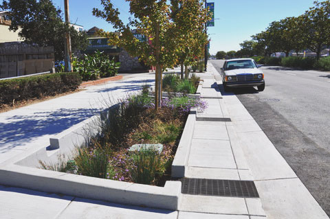
C.3 example from San Pablo Rain Gardens
California Gold | ˌkæləˈfɔrnyə – ɡoʊld
California native plants have several benefits including: providing habitat for animals, food for endemic insects, water-use reduction, and contributing to local character. In order to adapt to the unique climate of California, many plants go dormant during the dry and hot summer months. Instead of labeling the plants as “dead” in the summer months, we sometimes refer to this seasonal transformation as California Gold, a color that is a part of the character of our native plants.
Catch Basin | kætʃ – ˈbeɪsn
A catch basin or storm drain is a drain with the sole function of collecting rainwater from our properties and streets and transporting it to local waterways through a system of underground piping, culverts and/or drainage ditches. When stormwater goes directly into the municipal storm drain system, we lose the opportunity to filter pollutants or slow the volume of runoff.
Complete Street | com·plete street
This term refers to a holistic approach to designing a street. In addition to the auto-dominated travel lanes we are familiar with, complete streets include all modes of transportation, including bicycles, pedestrians, and transit. They make access safer for everyone, regardless of age, ability, income, race, or ethnicity.
Connectivity | con·nec·tiv·i·ty
As it relates to landscape architecture, the term refers to linking (pedestrian/bicycle/vehicular/transit) various destinations. It considers paths of travel and how places should be linked together for greater awareness, ease of use, and access. Connectivity is commonly mentioned when we think of: safe routes to schools, pathways to play, universal access and what makes a place pedestrian-friendly.
Gateway | ɡātˌwā
The statement piece that says, “You Have Arrived”. A gateway can be in the form of art pieces, entry monuments, large elements that span a street or walk, or other strong vertical landmark. They are often used as a first impression when entering a space.
DG | di – dʒi
DG is shorthand for decomposed granite which is a paving material like gravel, but finer and generally more stable. It’s formed from the natural weathering and erosion of solid granite: a tough, hard, igneous rock. The DG sold as landscaping material is typically composed of fine 3/8-inch (or smaller) particles; some may be no bigger than a grain of sand.
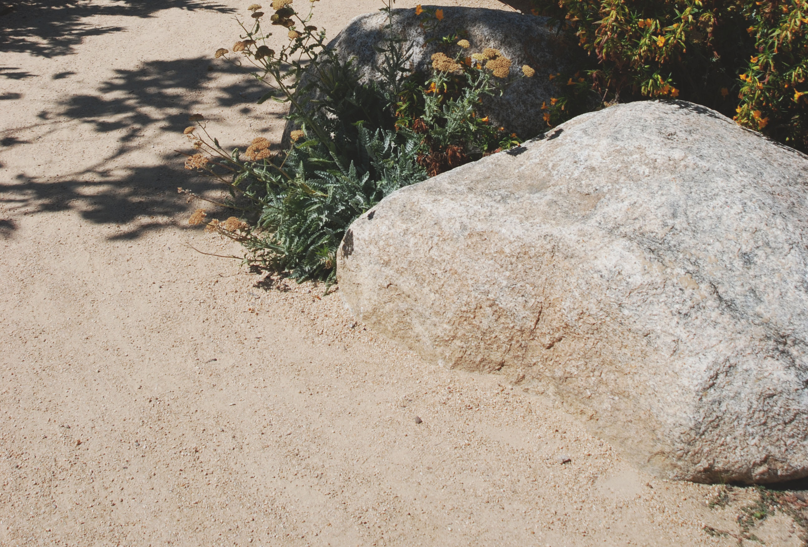
Decomposed granite example from Castro Valley Library
Finish Grade | ˈfɪnɪʃ – ɡreɪd
This is the final elevation and contour of the ground after cutting or filling and conforming to the proposed design.
Joint Trench | dʒɔɪnt – trɛntʃ
This occurs when dry utilities share a trench. For example, when the electric company and telephone company dig one trench and “drop” both of their service lines in.
Node | noʊd
A node is the intersection of at least two paths of travel. Nodes are used to provide additional space for people to maneuver around one another and maybe even offer seating to encourage chance encounters. A node is also a good location to provide wayfinding features, like signage, monuments, and planting to assist people in navigation.
Pedestal Pavers | ˈpɛdəstl – pi əˈvər
Pedestal paver systems are usually used on a roof that is sloped to drain. The system elevates and levels the walking surface while uniformly spacing the pavers for healthy air flow and proper drainage.
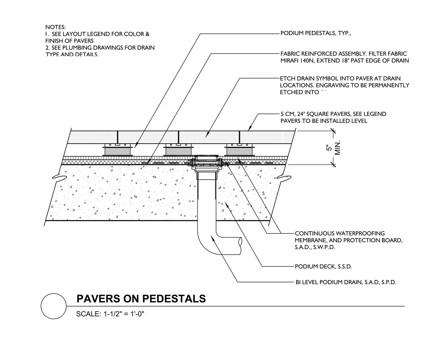
Pedestal Paver detail from Coliseum Transit Village
Plot/Plotting/Plotter | plɑt
If you walk into our offices you might see us plotting a large plan. Despite how that sounds, we aren’t developing the next scheme to take over the world. Plotting is just another word for printing but with a very large printer called a plotter. Plotter paper usually comes in large rolls to facilitate printing in various sizes.
Scale | skeɪl
Scale is how landscape architects determine how incrementally smaller a drawing is to real world measurements. Scale gives a line meaning. An LA might draw a planting plan at 20 scale. This means that for every inch of a line there are 20 feet in real world measurements. This allows a designer to quickly and accurately draw in a way that a contractor can read and build. A scale is also the physical tool used to measure the scale of a printed drawing. It looks like a rule with 3 sides and comes in architectural measurements (1/4” = 1’-0”, 1/8” = 1’-0”, etc.) and engineering measurements ( 1”=20’-0”, 1”=60’-0”, etc.).
Swale | swāl
A swale is a low channel on a site, that typically collects water from the surrounding area. They can be natural or man-made. They are often incorporated in our projects as a way to manage and infiltrate rainwater on site.
Traffic Calming | traf·fic calm·ing
Design methods to slow traffic, thereby promoting safety and promoting pedestrian and bicycle use. Some strategies for traffic calming, include: bulb outs, chicanes, roundabouts, flashing beacons, and speed bumps. These trends are recently emerging in Northern America, but are common practice in Australia and Europe.
Please Share & Follow Us